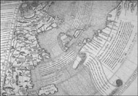
Johannes
Ruysch, 1507.
|
|
| |
| LIENS |
|
| Cartographie Histoire
et recherche Saint-Pierre
et Miquelon Liens
personnels Marchands
de cartes
| | BIBLIO | - AUBERT
DE LA RÜE E., 1944, St. Pierre et Miquelon. Éditions de l'Arbre Montréal
260 p.
- BIDEAUX
M., 1986, Bibliothèque du Nouveau Monde : Relations de Jacques Cartier
édition critique. Presses Universitaires de Montréal.
- BIGGAR
H. P., 1911, Precursors of Cartier. Ottawa.
- BIGGAR
H. P., 1903, The Voyages of the Cabots and of the Corte-reals to North America
and Greenland. Paris.
- BOURINOT
J. G., 1895, Notes in my library [review of Prowse's 'History of Newfoundland'
Gosse Cabot's landfall St. Pierre & Miquelon] In Week: A Journal for Men &
Women. Toronto July 19 vol. 12(34) pp. 799-801.
- COOK
J., 1766, Directions For Navigating on the Part of the South Coast of Newfoundland.
J. Mount et T. Page.
- CORMIER
M., 1997, Toponymie ancienne et origine des noms Saint-Pierre Miquelon et Langlade.
In Le Marin du Nord vol. VII. No 1. pp. 29-45.
- GANONG
W. F., 1964, Crucial Maps. University of Toronto Press Royal Society of Canada.
Édité par T. E. Lang.
- HARISSE
H., 1892, Discovery of North America. Amsterdam.
- HARISSE
H., 1900, Découverte et évolution cartographique de Terre-Neuve
et des pays circonvoisins 1497 1501 1769 : essais de géographie historique
et documentaire. H. Stevens Son & Stiles Paris Londres 420 p.
- PROWSE
D. W., 1895, St. Pierre et Miquelon The French Colony. In A History of Newfoundland.
2 vols. Macmillan London. pp. 564-86. Réimpression Mika Studio Belleville
Ontario 1972.
- Bibliographie
Générale de Saint-Pierre et Miquelon
|
|